
Chair’s Address
Mr Michael Burdett, Surveyor–General of South Australia
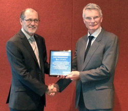
It is humbling to take on the role of ICSM Chair behind Mr Paul Harcombe, Chief Surveyor, Land & Property Information (LPI) of NSW. Paul has completed his term as ICSM Chair for 2012-2014 having made a significant contribution to the advancement and promotion of land and marine spatial infrastructure in Australia and New Zealand. Of particular note is the ICSM acceptance of sponsorship of seven of the Foundation Spatial Data Framework themes, the implementation of the Sub-surface Utilities Information standard, the lead in our datum modernisation program and the development of the Cadastre 2034 vision for Australia. I would like to thank Paul for his contribution and look forward to his ongoing role as Deputy Chair.
ICSM has set itself an ambitious work plan for the next two years with a particular focus on strengthening the Foundation Spatial Data held by Government within Australia and New Zealand. Establishing these datasets as authoritative in a sustainable manner can contribute significantly to our countries' ability to make better decisions from the intelligent use of location data.
I look forward to working with all sectors of our industry over the next two years.
Committee Members
Mr Bill Hirst, Surveyor-General of the ACT, retired on 5th December 2014 from ACT Government and ICSM after 7 years of membership. Bill's good humour and great insights will be sorely missed and the committee all wish him every success for his future endeavours.
ICSM would like to formally introduce and welcome its two newest members, Mr Craig Sandy (NT) and Mr Mark Dyer (NZ) and the fresh vision and contributions they will no doubt bring to the committee.
ANZLIC and the Foundation Spatial Data Framework (FSDF)
ICSM was invited by ANZLIC to be the sponsor of seven of the ten themes including Positioning, Place Names, Land Parcel and Property, Imagery, Transportation, Elevation and Depth and Land Cover themes.
The last few months have been focussed on developing the FSDF roadmaps for the various themes which were endorsed by ANZLIC at their recent meeting. These roadmaps establish a future vision for the themes along with a work plan to achieve it. Strong input from our industry partners will be vital in ensuring we maximise the benefits from this important work.
Real Tides Reveal Real Opportunity
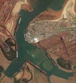
In April 2014, I had the pleasure to chair the ICSM – Permanent Committee on Tides and Mean Sea Level (PCTMSL) and Ports Australia Hydrographic Surveyors Working Group (PA HSWG) meetings in Port Hedland. The location was an excellent reminder to those of us now ‘desk–bound’ in demonstrating the significance of hydrographic surveying and tides are to operational ports. Both meetings were very constructive and everyone enjoyed the tour of the Port, but the highlight of the two days for me was the ‘Don Wallace Memorial Lecture’ presented by Mr Frans Schlack, Dredging Manager of the Port Hedland Port Authority (PHPA).
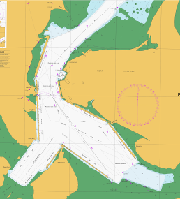
Frans’ presentation updated those assembled on the PHPA study into determining the ‘real tide’ and for a Port that regularly sails five to six fully–laden cape size vessels on a single tide, maximising the use of the available sea room has significant export benefits. Frans took us through the study activities and hit us with some enlightening facts that drove home the lost opportunity between surveying to an assumed Chart Datum (LAT) for a geographical area and a datum connected to the ellipsoid.
For every additional 10 centimetres of water gained, approximately 1200 ton more iron ore can be loaded. If the price of iron ore is $135 per ton and approximately 2000 ships a year visit the port, this would equate to lost export opportunity of approximately $324 Million per 10 centimetre of water not utilized. Armed with the knowledge of the true depths a more strategic dredging project can then be undertaken with not only increases in available drafts achieved but also increased tidal windows.
Captain Jenny Daetz, CSC, RAN
Deputy Hydrographer
Cadastre 2034 Final Strategy
After a successful consultation period, ICSM is now working on the final version of the Cadastre 2034 Strategy to be launched at Locate15 in Brisbane, in March 2015.
The strategy captures the trends and articulates the vision of what we believe the community will require of our cadastral system by 2034. It identifies where current information falls short of today's consumer expectations, and considers the user scenarios that could trigger changing needs in the future. Cadastre 2034 has been developed with input from a New Zealand perspective and Trans–Tasman collaboration remains an important feature of this strategy.
ICSM would like to thank all those who contributed input and support for Cadastre 2034.
The initial strategy is available on our website at http://www.icsm.gov.au/cadastral/index.html#nscri.
Welcome to our newest ICSM Executive members

Northern Territory: Mr Craig Sandy
Craig has worked predominantly in the private sector throughout his surveying career. He has maintained his registration in Queensland but has worked in many Australian jurisdictions.
His career has been diverse with experience in GNSS (Global Navigation Satellite Systems)for surveying and a range of applications and in the broader Spatial Sciences areas predominantly GIS.
Craig is well regarded nationally following his roles with Esri Australia, FIG 2010 Congress Sydney (International Surveyors Federation), Institution of Surveyors, Australia and the Surveying and Spatial Sciences Institute.
New Zealand: Mr Mark Dyer

Mark has been in professional survey practice since 1986 working in Auckland and Bay of Plenty survey and planning consultancy firms. He was the Managing Director of Rotorua–based survey and planning consultancy Canmap Hawley Limited, he holds graduate qualifications in surveying and post graduate qualifications in resource and environmental planning.
Mark’s career includes roles as a Hydrographic Officer with the Royal New Zealand Navy, President and Fellow of the New Zealand Institute of Surveyors, and membership of the New Zealand Planning Institute and the Royal Institution of Chartered Surveyors.
9. Next ICSM meeting
The next meeting will be held in Darwin, Northern Territory on 19 & 20 May, 2015.
Previous news letters
- December 2013
- August 2013
- October 2012 (.pdf file, 1.9 MB)
- February 2012 (.pdf file, 3.5 MB)
- June 2011 (.pdf file, 2.9 MB)
- December 2010 (.pdf file, 2.4 MB)
- June 2010 (.pdf file, 3.1 MB)
- December 2009 (.pdf file, 5.1 MB)
- June 2009 (.pdf file, 5.1 MB)
- December 2008 (.pdf file, 2.1 MB)
- June 2008 (.pdf file, 1.0 MB)
- December 2007 (.pdf file, 0.7 MB)
- June 2007 (.pdf file, 0.8 MB)
- December 2006 (1.7 MB)
- June 2006 (.pdf file, 1.2 MB)
- December 2005 (2.5 MB)
- June 2005 (.pdf file, 1.5 MB)
- 2004 (0.7 MB)
- December 2003 (.pdf file, 1.1 MB)
- June 2003 (.pdf file, 91.0 MB)
- November 2002 (.pdf file, 0.7 MB)
- June 2002 (.pdf file, 0.7 MB)
- November 2001 (.pdf file, 0.5 MB)
- May 2001 (.pdf file, 0.4 MB)
- June 2000 (.pdf file, 2.1 MB)