
The Australian Government has committed $225m to provide 10 cm (or better) accurate positioning to anyone, anytime, anywhere in Australia in the near future. This is a significant improvement from the 5-10 m accuracy you can currently achieve using GPS enabled devices.
In anticipation for the growing use and reliance on positioning technology, the Permanent Committee on Geodesy is leading the upgrade of a number of elements of Australia’s Geospatial Reference System including the static datum from GDA94 to GDA2020.
Key points:
- GDA2020 is a static datum – just like GDA94
- A ‘static’ datum means that the coordinates of features (e.g. roads, buildings and property boundaries), do not change with time
- The upgrade to GDA2020 is to ensure spatial data can be more closely aligned to positions observed using Global Navigation Satellite System (e.g. GPS)
- GDA2020 is available for use now
In anticipation for the growing use and reliance on positioning technology, the Permanent Committee on Geodesy led the development of the upgrade of Australia’s ‘static / plate fixed’ datum from the Geocentric Datum of Australia 1994 (GDA94) to GDA2020 which was released in 2017. A ‘static’ datum means that the positions of features (e.g. roads, buildings and property boundaries), do not change over time despite the ongoing changes in the Earth’s surface (e.g. plate tectonic motion). This is beneficial for many applications where it is easier if the coordinates of features do not change (e.g. a major road development project).
Video courtesy Small Island Studio
In contrast, Global Navigation Satellite Systems (GNSS) base their coordinates on a framework that is fixed to the centre of the Earth around which satellites are orbiting. These frameworks are called ‘time-dependent reference frames / earth fixed’ in which the positions of features change with time due to plate tectonic motion.

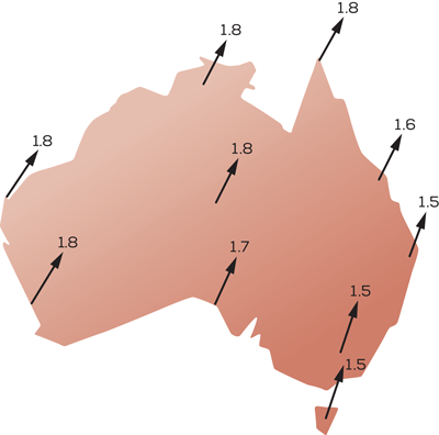
Historically, location differences of a metre or so have not been an issue, because GNSS has traditionally only provided accuracy of 5 – 10 m. In fact, when GDA94 was adopted in 2000, GPS positions were ‘accurate’ to 100 metres. Since then, however, two important things have happened: 1) Australia’s tectonic plate – the Earth’s fastest moving continental plate – has moved about 1.5 metres northeast (approximately 7 cm / yr), and 2) positioning technology has evolved considerably. By 2020, Australia will have moved 1.8 metres northeast of where it was in 1994, and many of us will own devices that pinpoint places as small as, well, a smartphone. With real-time access to precise satellite positioning at our fingertips, we’ll notice discrepancies with GDA94-mapped features. The upshot is that Australia’s datum needs updating so we can reap the benefits of 21st Century positioning technology.
GDA2020 is defined in the National Measurement (Recognized-Value Standard of Measurement of Position) Determination 2017 by the coordinates on 109 GNSS Continuously Operating Reference Stations known as the Australian Fiducial Network (AFN). ANZLIC – the Spatial Information Council have announced that 30 June 2020 is the date by which ANZLIC member agencies in Australian states and territories will be ready to deliver and receive national scale foundation spatial data on GDA2020.
GDA2020 coordinates can be accessed via:
- Commonwealth, state and territory geodetic and survey databases
- GNSS CORS stations with Regulation 13 Certification issued by Geoscience Australia
- Government (https://www.auscors.ga.gov.au/) or commercial real-time services , or
- via transformation of GDA94 to GDA2020 coordinates using the transformation products and tools published by ICSM.
The standard map projection associated with GDA2020 is the Map Grid of Australia 2020 (MGA2020), a transverse Mercator projection that conforms to the internationally standardised Universal Transverse Mercator Grid system.
For more information on GDA2020, please refer to the following links:
- GDA2020 Fact Sheets
- GDA FAQ
- GDA transformation products and tools
- GDA2020 and GDA94 technical manuals
- Connect with us
Datum Research projects