
The Australian Geospatial Reference System is the collection of:
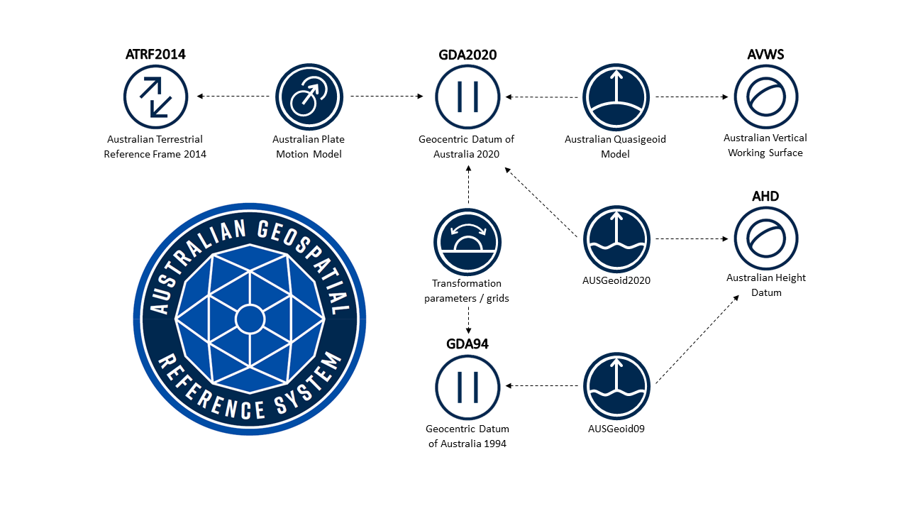
- datums (e.g. Geocentric Datum of Australia 2020, Australian Height Datum), reference frames (e.g. Australian Terrestrial Reference Frame) and working surfaces (e.g. Australian Vertical Working Surface) used to define latitude, longitude and height throughout Australia;
- infrastructure, including a national network of Global Navigation Satellite System Continuously Operating Reference Stations and survey marks to provide an authoritative and accurate network in support of positioning applications;
- models describing dynamic, geophysical processes that affect spatial measurements; and
- standards to ensure positioning information is Findable, Accessible, Interoperable and Reusable (e.g. ISO / OGC / GeodesyML).
The Australian Geospatial Reference System is managed by the Intergovernmental Committee on Surveying and Mapping Geodesy Working Group.
Australian Geospatial Reference System Compendium
Download the Australian Geospatial Reference System Compendium here.
The Australian Geospatial Reference System Compendium is a document which explains why, and how, Geoscience Australia along with the states and territories modernised the foundations for positioning in Australia.
In anticipation of the growing use and reliance on positioning technology, the Intergovernmental Committee on Surveying and Mapping Geodesy Working Group (ICSM GWG), spent over 10 years upgrading elements of the Australian Geospatial Reference System (AGRS) to improve the accuracy with which spatial data can be aligned and combined with precise positioning data. The AGRS upgrade includes:
-
Geocentric Datum of Australia 2020 (GDA2020): Australia’s new static datum
-
Australian Terrestrial Reference Frame 2014 (ATRF2014): Australia’s first time-dependent coordinate reference frame, which moves with the Australian plate (~7 cm / yr).
-
DynAdjust: World first software able to compute a continental scale least squares adjustment of all geodetic data (~2 million measurements) to define GDA2020 and ATRF2014.
-
AUSGeoid2020: World first geoid model which provides location specific uncertainty; thus providing users with a rigorous method of deriving Australian Height Datum heights with uncertainty directly from GNSS.
-
Commonwealth Law Changes: Worked with National Measurement Institute to update the Recognised Value Standard for Measurement of Position in Australia to legally recognise both static (GDA2020) and time-variable coordinate reference frames (ATRF2014).
-
Australian Vertical Working Surface (AVWS): A new vertical datum enabling more accurate conversion of GNSS heights to mean sea level heights.
-
GeodesyML: Development and release of the Geodesy Markup Language standard, which aims to make geodetic data more Findable, Accessible, Interoperable and Reusable (FAIR).
These upgrades to the AGRS are an outstanding example of how members of state, territory and Commonwealth governments have collaborated to resolve a challenging problem and deliver an authoritative foundation for improved decision making.